

JACKSONVILLE, Fla. – Hurricane Milton on Tuesday was still making its way to the west coast of Florida and is forecasted to hit the Tampa Bay area as a catastrophic Category 3 with a storm surge of 10 to 15 feet.
MORE | St. Johns County issues mandatory evacuations for zones A, B and F ahead of Hurricane Milton | Hurricane Milton slows down but remains extremely dangerous Category 4 with increasing winds
Recommended Videos
At the same time, the rest of the state will feel hurricane winds and see pounding rain as the storm crosses Florida on Thursday, bringing storm surges on both sides of the Florida coastline.
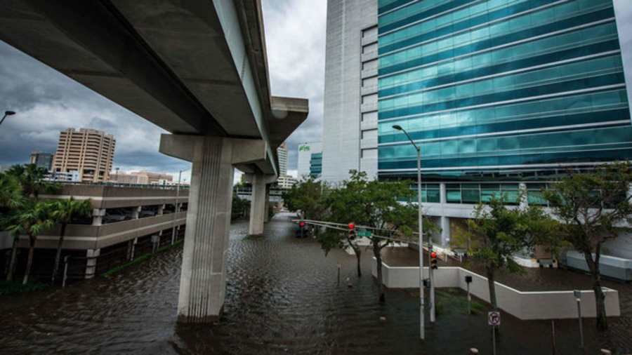
Between 3-5 feet of storm surge could affect the coastline along Duval and St. Johns counties as well as Southeast Georgia. Along the St. Johns River, a 2-4 foot storm surge is predicted, which could lead to flooding in downtown Jacksonville, San Marco, and beyond.
Along with all the storm surge warnings, Florida will also be inundated with rain.
Jacksonville and the surrounding areas could see 6 to 10 inches of rain, which could create even more flooding, especially in low-lying and flood-prone areas.
“So remember that it only takes two feet of storm surge to move a car. I know you’re seeing all these big numbers in other places, but still, two feet of storm surge can move a car. So make sure you are not driving through that even after the storm passes,” Mayor Donna Deegan said on Tuesday.
Deegan said tidal flooding will peak Thursday afternoon and again on Friday and continue through the weekend.
Forecasters are comparing the expected effects of Hurricane Milton to past hurricanes like Irma. During that storm, Jacksonville experienced the worst flooding in the city’s 250-year history. Downtown streets became rivers. Homes in San Marco and across the city were flooded. Along both sides of the St. Johns River, businesses were shuttered for months in the aftermath.
“If you flooded during Irma, Ian, or Nicole, you are at risk of flooding during Milton,” the National Weather Service Jacksonville said.
Florida has been inundated with rain for the past few months making Florida extremely saturated and with an above-average rainy season so far, prone to wider flooding.
Other Areas that will be affected
- Anclote River, FL to Englewood, FL...10-15 ft
- Tampa Bay...10-15 ft
- Englewood, FL to Bonita Beach, FL...6-10 ft
- Charlotte Harbor...6-10 ft
- Yankeetown, FL to Anclote River, FL...5-10 ft
- Bonita Beach, FL to Chokoloskee, FL...4-7 ft
- Suwannee River, FL to Yankeetown, FL...3-5 ft
- Chokoloskee, FL to Flamingo, FL...3-5 ft
- Altamaha Sound, GA to Edisto Beach, SC...2-4 ft
- Sebastian Inlet, FL to Port Canaveral, FL...2-4 ft
- Dry Tortugas...2-4 ft
- Flamingo, FL to Card Sound Bridge, FL...1-3 ft
- Indian Pass, FL to Suwannee River, FL...1-3 ft
- Edisto Beach, SC to South Santee River, SC...1-3 ft
- Florida Keys...1-3 ft
When to Evacuate?
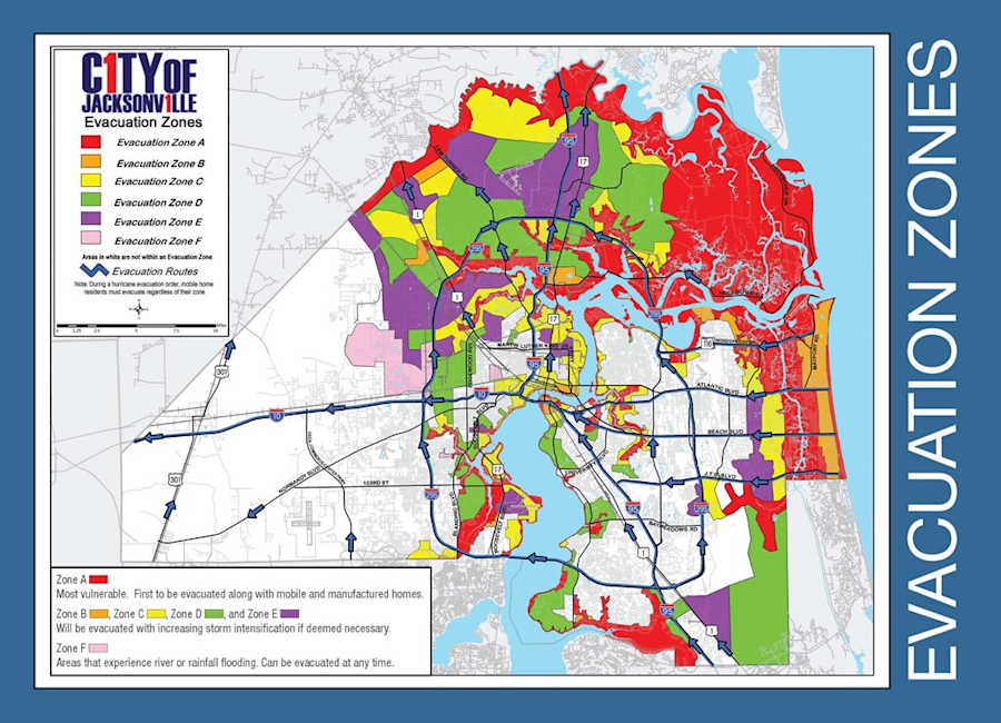
If you are in a low-lying or flood-prone area or near the St. Johns River / Jacksonville Beaches, it is important to know your evacuation zone.
According to FEMA, during a hurricane, the common sources of injury and death included drowning from floods and storm surges and trauma from debris carried by high-speed winds.
If you are asked to evacuate, it is critical that you listen to your local authorities. Make sure you bring your ID, along with any mail or proof of residence, in the event you evacuate.
What is a storm surge?
According to the National Weather Service (NWS), a storm surge is an abnormal water rise generated by a storm over and above the predicted astronomical tide.
Storm surge is caused primarily by the strong winds in a hurricane or tropical storm.
The stronger the system is, the larger the storm surge will be.
Relevant Facts (from Weather.gov):
- Population density increased 32% in coastal counties along the Gulf of Mexico coastline from 1990 to 2008
- 27% of major roads in the Gulf region are at or below 4 ft. elevation
What Influences a Storm Surge?
- Central Pressure
- Storm Intensity
- Storm Forward Speed
- Width and Slope of the Ocean Bottom
- Size
- Angle of Approach to Coast
- Shape of the Coastline
- Local Features
How does storm surge happen?
According to an in-depth explanation by USA Today, in the open ocean, hurricane winds push water toward the center of the storm. Instead of piling up, the water spirals downward and flows outward.
As the water is pushed downward, some is pushed out to sea, and some is pushed toward the coast.
As the storm approaches land and shallow water, the ocean floor blocks the outflowing water, causing the ocean to surge onto land.
Want more information regarding storm surges? Visit Weather.gov.


