

JACKSONVILLE, Fla. – Hurricane forecasting has vastly improved throughout the decades.
Today, we have more information available to help make forecasting more accurate. Granted, modeling is always uncertain, but it’s still better than in the past.
Recommended Videos
With all these sophisticated models and the National Hurricane Center’s (NHC) ever-changing technology, it’s not hard to see why people need clarification on the difference between cone and spaghetti models.
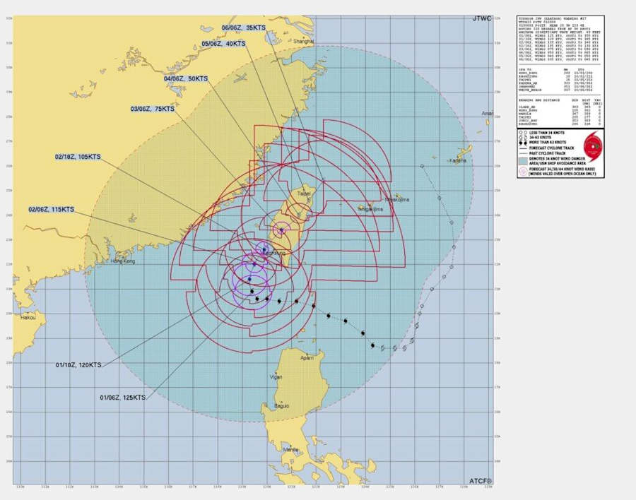
Many sights offer spaghetti models, but there are only two sites that offer cones: the NHC only deals with hurricanes in the Atlantic, Pacific, and Central Oceans, while in other parts of the world, a different type of cone is offered for typhoons through the Naval Meteorology and Oceanography Command or the Joint Typhoon Warning Center (JTWC).
RELATED: Understanding spaghetti models: How they help with hurricane prediction insight
So, it’s understandable why there is much confusion regarding modeling.
Spaghetti models — also known as Spaghetti plots — are a forecasting tool to give an idea of where a storm could make an impact. It gives forecasters a starting point, and end, along with intensity. These models only go out a few days, anything greater leads to a huge spread.
These spaghetti models are based on constant shifts due to the changes in the surrounding pattern in the atmosphere.
In return, the NHC takes the spaghetti plots and makes a cone out of them. This cone, known as the cone of error, begins very wide and gradually tightens as the storm approaches the coastline. Normally, the hurricane center will provide an error with a particular mile of width depending on how big or small the system is, and as the storm gets closer, those miles get smaller.
For example, if a hurricane has an eye wall 25 miles wide and 100 miles wide of tropical-storm-force winds, it will place an approximate distance error of 100 miles. This is not to be confused with the exact area of landfall, as that is very wide and gets smaller as it approaches landfall.
Hurricanes are notorious for shifting. The cone is significant: If it shifts up or down, it warns everyone in those areas of the impacts. It also gives officials time for evacuations or other valuable information to save people’s lives.
According to the NHC, “The cone represents the probable track of the center of a tropical cyclone and is formed by enclosing the area swept out by a set of circles (not shown) along the forecast track (at 12, 24, 36 hours, etc). The size of each circle is set so that two-thirds of historical official forecast errors over a 5-year sample fall within the circle. The circle radii defining the cones in 2024 for the Atlantic, Eastern North Pacific, and Central North Pacific basins are given in the table below.”
It doesn’t mean you are free and clear if you are outside the cone. Many parts will still feel impacts such as rain, winds, and tornadoes, but not as great as the cone portions would.
The NHC uses mph, while the JTWC uses knots. The JTWC cone is very different, with a forecast of 34/50/64 knot wind Radii (Winds valid over open ocean only). On their cone graphics, you will see knots only, while the NHC puts letters in their cone.
For more information about typhoons, view here.