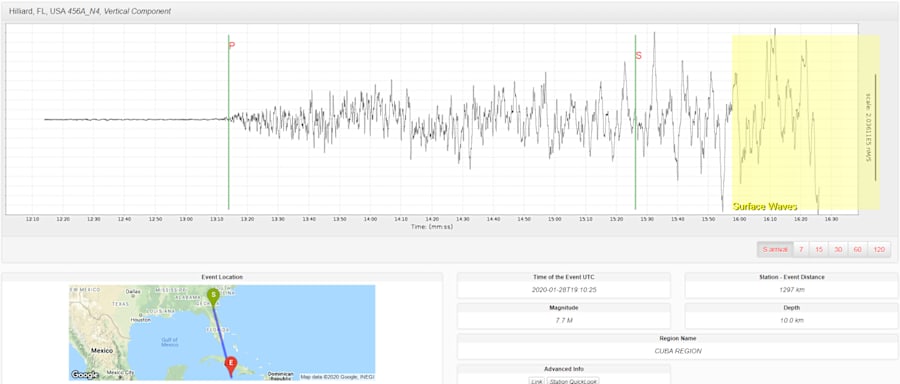
People in Miami, 440 miles from the epicenter of Tuesday’ Caribbean earthquake, felt the ground shake. And while people in Hilliard didn’t feel the earth move, sensitive instruments did record the earth movement.
The magnitude 7.7 quake between Cuba and Jamaica is one of the strongest in the past 100 years along an area where a break in the Earth’s crust is slipping past each other sideways along the Oriente Fault zone.
Ground shaking caused tall buildings in Miami to shake as longer period earthquake ground waves traveled out away from the Caribbean.
People in north Florida could not perceive any movement but seismic measuring devices 605 miles from the epicenter in Hilliard did record small earth movements.
The ground shifted less than the width of a human hair so it’s not surprising the shake wasn’t felt locally.
Seismic activity reached North Florida quickly. It took just over 13 minutes for the compressional P waves to travel a curved path through the mantle from the earthquake to reach seismic instruments in Hilliard.

Slower surface waves followed 16 minutes later. These slower waves travel along the perimeter of the Earth from the earthquake to the recording station.
As seismic (earthquake) waves travel through the Earth, they cause the ground to move and a network array of 400 seismic sensors measuring the amount of earth movement captures the progress.
Seismic waves traveling away from the earthquake appear to sweep across Florida and into the nation’s Pacific Northwest in the above visualization from the Incorporated Research Institutions for Seismology.
Each circle in the visualization represents earthquake recording stations and the color indicates the amplitude, or height, of the earthquake wave detected by the station’s seismometer.
The color of the circle changes as waves of differing amplitude travel past the seismometer. Blue represents downward ground motion, red represents upward ground motion, and darker colors indicate larger amplitudes.
Sideways strike-slip movements like in this earthquake are less likely to cause tsunamis compared to vertical plate boundary movements between the North America and Caribbean Plates.


