JACKSONVILLE, Fla. – Rain was steady and heavy overnight into Sunday morning, flooding roads on Jacksonville’s Westside.
Several cars stalled out and areas were blocked off because of flooding in low-lying areas on Sunday, which is a Weather Authority Alert Day through 6:30 p.m.
Of the 24-hour rainfall totals as of 10:30 a.m., according to the National Weather Service Jacksonville, the highest amount of 5 to 7 inches across Northeast Florida was in the area of the Westside. A flood warning was in effect until 11:30 a.m. for Duval and St. Johns counties.
Here are the 24-hour rainfall amounts as of 1030 am 6/7/2020. Highest amount of 5 to 7 inches across NE FL was on the West-Southwest and SW part of JAX were flooding took place. https://t.co/ebeMSzF5SD Another round of showers and thunderstorms expected later today. #jaxwx
— NWS Jacksonville (@NWSJacksonville) June 7, 2020
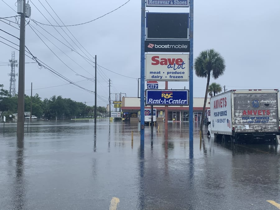
As of 10:40 a.m., North Edgewood Avenue near Broadway Aveway in Jacksonville was flooded. Water was in the roadway and in the parking lot of the nearby plaza. The Jacksonville Sheriff’s Office blocked off Edgewood Avenue.
“I’m a homeowner. All this water is flooding and damaging my house, my property and everything,” said Jerome Anderson, who lives off Edgewood Avenue.
Anderson said the flooded roads make it difficult to get home.
“It’s very often. There needs to be some kind of system to get this water up and out of here. It’s really bad for the people in the community. We can’t get in and out,” Anderson said. “If you go back around this area, it’s even worse. Some people can’t even come out the door and can’t even get out because of the water.”
The Florida Highway Patrol said all lanes at Interstate 10 and Cassat Avenue were closed just before 10 a.m. due to flooding. Police were seen directing traffic and diverting drivers because the water was so deep.
Just after 9:40 a.m., the NWS said a car was stalled at the intersection of Edgewood Avenue and Park Street, which was “totally flooded out.”
Car stalled on Edgewood & Park intersection - roadway "totally flooded out". Rain pushing toward the coast, and moving more rapidly eastward. Good news. More showers & thunderstorms moving into the west coast of FL, and will push northeast in NE FL this afternoon. #jaxwx
— NWS Jacksonville (@NWSJacksonville) June 7, 2020
The NWS reported about 9:20 a.m. that there was up to 3 feet of water at King Street and McCoy Creek Boulevard. The NWS said the roadway near Lane Avenue and Normandy Boulevard was inundated, and cars were stalled in “river-like” conditions along Edgewood and Cassat avenues.
Around McCoys Creek in Jacksonville, there was excessive rainfall. The NWS said about 9 a.m. that rainfall fall rates had been 3 to 6 inches per hour over the Basin.
Storm drains were seen overflowing in several areas. Officials warned drivers who encountered flooded roadways to turn around.


McCoys Creek area
Earlier Sunday morning, according to the Sheriff’s Office, an officer responding to a stalled vehicle was injured in a semi crash on Interstate 295 near Gate Parkway. Police said two other people were also hurt.
The Jacksonville Fire and Rescue Department also said a hazmat team responded to a semi that was leaking fuel after a crash on Interstate 95 at Airport Road.
| |
Bad weather also prompted the closure of the COVID-19 testing site at Lot J outside TIAA Bank Field on Sunday.
Areas of heavy showers overnight flowing out of the Gulf of Mexico from Tropical Storm Cristobal continued to track northward through Northeast Florida early Sunday and became more of a mess for areas in southern Georgia through the morning.
ONLINE: Interactive radar | View/share with StormPins
The last round of storms that ended about 10 a.m. dumped another 2 to 4 inches around Jacksonville, leaving Hyde Park area (Normandy Boulevard and I-295) with 7.02 inches of rain -- and more to come.
Even though the worst of the rains are over, any significant rain will add to travel issues and some additional flooding.
Duval County should see another inch before the end of the day.