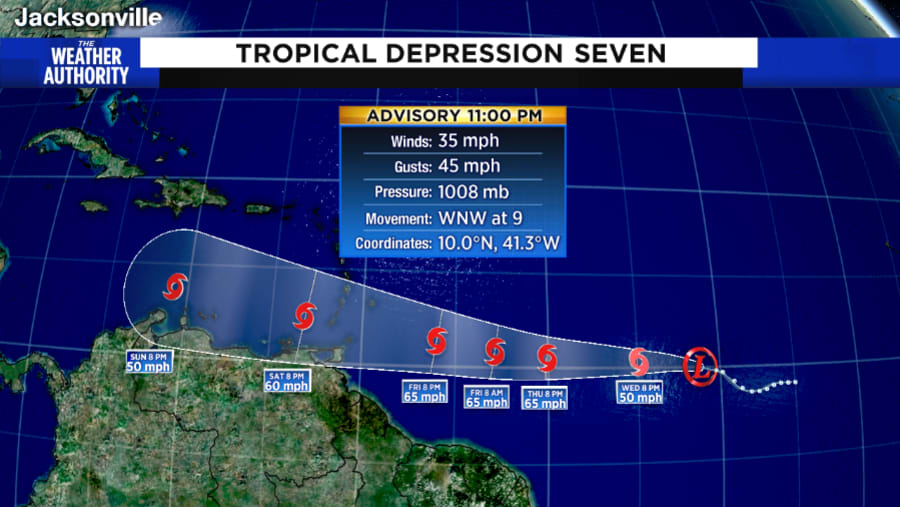
JACKSONVILLE, Fla. – And on the 21st day of July, Tropical Depression #7 developed way, way, way out in the Tropical Atlantic Ocean -- about 1,350 miles east of the Windward Islands. This is also about 2,875 miles away from Jacksonville.
Maximum winds are estimated by satellites at around 35 mph. TD #7 is moving west at 9 mph. This system will remain very, very far to the south, which will allow it to potentially develop into Tropical Storm Gonzalo.
Recommended Videos
The National Hurricane Center believes this will become Tropical Storm Gonzalo (”gohn- SAH-loh”) sometime Wednesday morning.
The track from there is into the Caribbean Sea. Strangely, this is where many tropical depression/storms and even a few hurricanes have weakened and dissipated. Yes, the eastern part, especially the southern part of the Eastern Caribbean Sea is often called the “graveyard of the tropics.” Basically, the interaction of South America (to the south) and the strong trade winds (to the north) tend to deform the circulation center. The result is a weaker system.
I should point out this is not always the case. The two exceptions are when the tropical system has a tight internal circulation and is very small, or very large. The other instance is during the Fall, especially in October, systems in the Eastern Caribbean Sea can rapidly develop.
Tropical Depression #7 has a tight circulation and is at a low latitude (way south) and these two details may allow for TD #7 to outperform, remain stronger than forecast models currently suggest.
Most models do in fact dissipate this system in the Eastern Caribbean Sea. The NHC does not, keeping it as a moderate Tropical Storm through this weekend.


