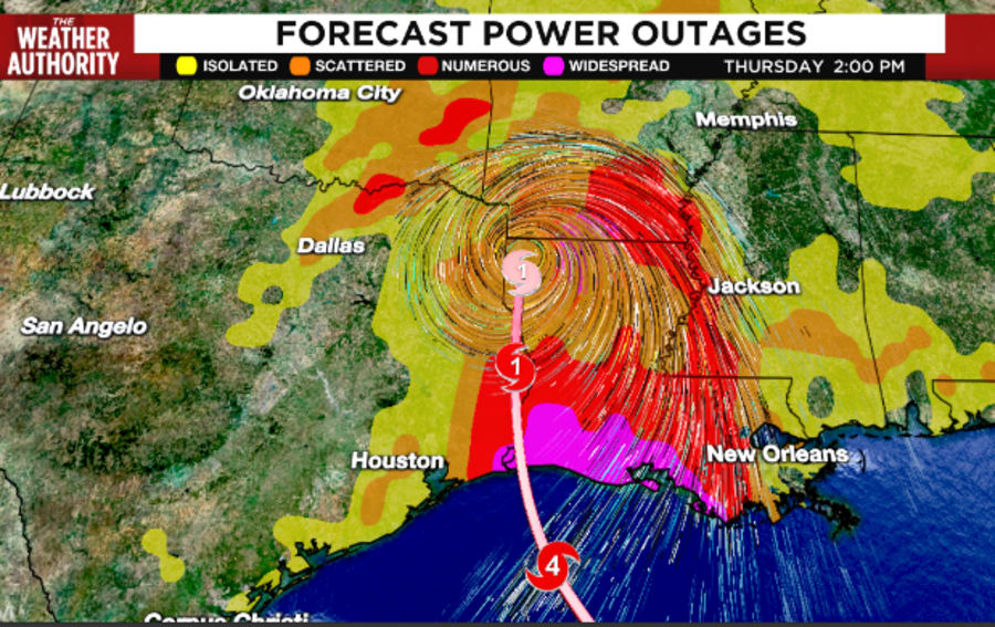
JACKSONVILLE, Fla. – Update: The hurricane is now moving northward with the initial motion estimated to be 15 mph. Laura is expected to continue moving northward through today which should take the core of the system across Louisiana and Arkansas. After that, Laura will likely become embedded in the mid-latitude westerlies, and the much weaker cyclone is forecast to move quickly east-northeastward across the southeast U.S. and the mid-Atlantic states on Friday and Saturday. By late in the weekend and early next week, Laura, or its extratropical remnants, should accelerate northeastward across the western Atlantic. Now that Laura is inland, rapid weakening is forecast and it will likely become a tropical storm later today and a tropical depression on Friday. It should be noted that strong hurricanes like Laura are not just coastal events. Even though Laura’s highest winds will decrease quickly as it treks inland, significant impacts from heavy rains and strong wind gusts are likely through at least tonight across portions of Louisiana and Arkansas. Some strengthening as an extratropical cyclone is expected when the storm moves over the Atlantic waters late this weekend and early
Laura rapidly strengthened with recent visible satellite imagery revealing a very distinct 25 nautical- mile-wide eye embedded in a symmetric central dense overcast. The upper-level outflow has also become well established in all quadrants. An Air Force Reserve hurricane hunter aircraft that is still investigating the hurricane has reported peak 700-mb flight-level winds of 156mph and SFMR winds of 139mph in the northeast eye wall. These data support an initial intensity of 143 mph, which is an increase of 63 mph over the past 24 hours.
Recommended Videos
Laura still has about 12 hours remaining over the warm waters of the northwest Gulf of Mexico waters, but increasing southwesterly shear around the time of landfall and the possibility of an eye wall replacement could result in some fluctuations in intensity this evening, but Laura is expected to remain an extremely dangerous category 4 hurricane through landfall tonight.
Hurricane-force winds extend outward up to 60 miles from the center and tropical-storm-force winds extend outward up to 205 miles. Tropical-storm-force winds have reached the coast of Louisiana and an observing site at Eugene Island recently measured sustained winds of 39 mph and a gust to 64 mph.
The center of Laura is forecast to move over northwestern Louisiana tomorrow, across Arkansas Thursday night, and over the mid-Mississippi Valley on Friday. Rapid weakening is expected after Laura makes over land.

Unsurvivable storm surge with large and destructive waves will cause catastrophic damage from Sea Rim State Park, Texas, to Intracoastal City, Louisiana, including Calcasieu and Sabine Lakes. This surge could penetrate up to 30 miles inland from the immediate coastline. Only a few hours remain to protect life and property and all actions should be rushed to completion.
Hurricane-force winds are expected tonight in portions of the hurricane warning area from San Luis Pass, Texas, to west of Morgan City, Louisiana, with catastrophic wind damage expected where Laura’s eye wall makes landfall. Hurricane-force winds and widespread damaging wind gusts will spread well inland across portions of eastern Texas and western Louisiana early Thursday.
Widespread flash flooding along small streams, urban areas, and roadways is expected to begin this afternoon into Thursday from far eastern Texas, across Louisiana and Arkansas. This will also lead to minor to isolated moderate freshwater river flooding. The heavy rainfall threat and localized flash and urban flooding potential will spread northeastward into the middle-Mississippi, lower Ohio and Tennessee Valleys Friday night and Saturday.
From this afternoon through Friday, Laura is expected to produce rainfall totals of 5 to 10 inches, with isolated maximum amounts of 15 inches across portions of the northwestern Gulf Coast from western Louisiana to far eastern Texas, and northward into much of Arkansas. This rainfall will cause widespread flash and urban flooding, small streams and creeks to overflow their banks, and minor to isolated moderate freshwater river flooding. By Friday into Saturday, Laura will produce rainfall totals of 2 to 4 inches, with isolated maximum amounts of 6 inches across the mid-Mississippi and portions of the Lower Ohio and Lower Tennessee Valleys. This rainfall may lead to localized flash and urban flooding and rapid rises on small streams.


