After the coldest Christmas Day we’ve had in 16 years, we are in for a widespread Hard Freeze for most areas, only St Johns County and Coastal Duval counties are not under a Hard Freeze Warning, just a normal Freeze Warning. The difference is mainly how cold the area will be for how long, and areas under a Hard Freeze Warning tonight may need to protect exposed pipes.
We expect the areas under a Hard Freeze Warning to see overnight lows between 23-29° and need to drip or wrap exposed pipes in addition to protecting your pets and plants. Coastal Duval and St Johns counties do not need to worry about pipes, but should protect their pets and plants, with overnight lows between 30-32° expected. ALL areas need to be concerned with heating your home safely, we often see a rash of house fires, mainly due to space heaters, on night like tonight.
Recommended Videos
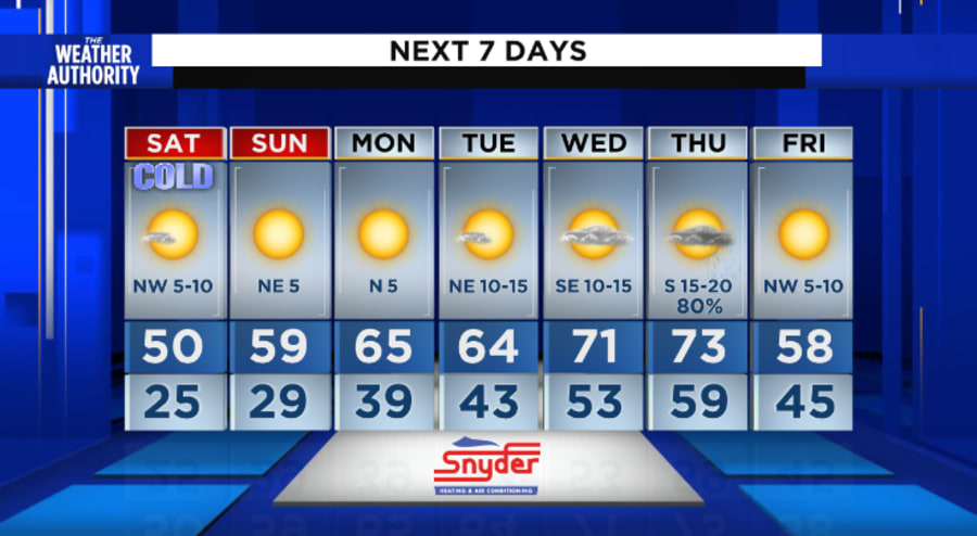
Saturday starts out with widespread frost (share those fun frost pictures with us in the pins tabs of the News4JAX weather authority app) and only warms up to around 50° under sunny skies with lighter winds out of the northwest between 5-10 mph.
Saturday night we are in for a lighter freeze with temperatures getting down into the upper 20s and low 30s.
Sunday will be sunny and ever-so-slightly less cold, with temperatures topping out in the upper 50s.
Temperatures more akin to the winter weather we are familiar with are back on Monday- warming into the cool mid 60s for the afternoon under mostly sunny skies.
Tuesday we will wake up in the low 40s and warms into the mid 60s.
The 70s are back Wednesday and Thursday, but showers move in Thursday ahead of another cold front late on Thursday and shoves us back into the chilly zone on Friday.