

JACKSONVILLE, Fla. – Brrrrrr! Monday feels miserably cold. In addition to the actual temperatures which are chilly all by themselves, we have gusty cold winds out of the northwest close to 20 mph, making it feel even colder than it actually is.
We call that the wind chill temperature, and on days like Monday the wind chill is what you should plan for and dress for if you have to be outside.
Recommended Videos
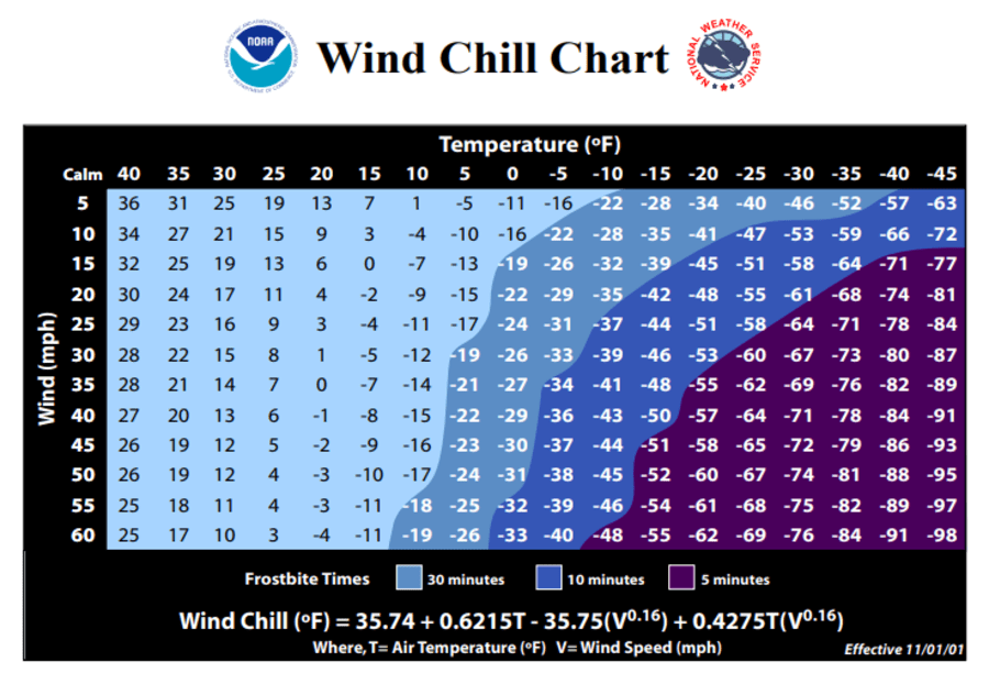
According to the National Weather Service, the wind chill temperature is how cold people and animals feel when outside. Wind chill is based on the rate of heat loss from exposed skin caused by wind and cold. As the wind increases, it draws heat from the body, driving down skin temperature and eventually the internal body temperature. Therefore, the wind makes it FEEL much colder. If the temperature is 0°F and the wind is blowing at 15 mph, the wind chill is -19°F. At this wind chill temperature, exposed skin can freeze in 30 minutes.
Our temperatures fell all day Monday instead of rising. We started out in the upper 50s and had fallen into the upper 40s by noon. The wind made the chilly temperatures all the more unbearable, out of the northwest sustained at 18 mph with gusts around 26 mph. That made the actual temperature of 47° feel like 40.
The NWS Wind Chill Temperature (WCT) index uses advances in science, technology, and computer modeling to provide an accurate, understandable, and useful formula for calculating the dangers from winter winds and freezing temperatures. The index does the following:
- Calculates wind speed at an average height of 5 feet, the typical height of an adult human face, based on readings from the national standard height of 33 feet, which is the typical height of an anemometer
- Is based on a human face model
- Incorporates heat transfer theory based on heat loss from the body to its surroundings, during cold and breezy/windy days
- Lowers the calm wind threshold to 3 mph
- Uses a consistent standard for skin tissue resistance
- Assumes no impact from the sun, i.e., clear night sky.
You may have heard humidity discussed more often in relation to our heat than our cold. Perhaps you’ve been a part of a discussion comparing the “dry heat” of Nevada to our more humid heat feeling more oppressive. The moisture content of the air also makes a difference in how cold it feels also, the more moist the cold air is, the chillier it can feel, it is called a “damp cold.”
Monday’s relative humidity levels ranged between 70-80%, making for a very damp chill.
Monday night’s forecast
A Wind Chill Advisory has been issued for our area Monday evening until 9 a.m. Tuesday. Strong northwest winds will produce very cold wind chill temperatures with wind chills as low as 25° degrees expected. Dangerously low wind chill values could result in hypothermia if precautions are not taken. Use caution while outside. Wear appropriate clothing, a hat, and gloves. Protect people and pets from the cold and wind.
The winds will not fade overnight, expect sustained winds around 18 mph and gusts of wind just shy of 30 mph. The elevated winds will make our mid-30s feel colder than they actually are, but elevated winds overnight actually inhibit us from cooling down as much as we could. So even though we feel colder, the winds are keeping us from seeing actual colder temperatures.
In this case, the winds will keep us from seeing widespread freezing temperatures. Overnight most of us will see mid-30s, but we will feel like the mid to upper-20s.
With calmer winds and clear skies Tuesday night into Wednesday morning, we are more likely to see a widespread freeze.

