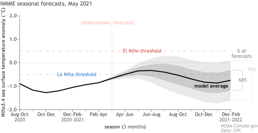
It’s all over! NOAA declared La Niña officially over, and this is good news for the upcoming hurricane season.
La Niña is the phase of cooler water in the Pacific Ocean. It is responsible for weather connections around the globe, one of which can enhance Atlantic hurricane activity like the record 30 storms we had in 2020.
Recommended Videos
La Niña continued to weaken in April and early May, and NOAA says neutral conditions are likely to persist through summer.
This news isn’t a total storm squasher, but conditions over the Atlantic will see a bit more shear or unfavorable winds in areas where hurricanes develop which should prevent another record number of hurricanes.

Seasonal hurricane forecasters are set to release a final prediction May 20 for the start of the June 1 hurricane season and the numbers will account for the warm up in the Pacific.
It might sound confusing, but warmer Pacific sea surface temperatures reduce Atlantic hurricane activity, though warmer Atlantic water will increase tropical cyclones directly by supplying extra moist war air to fuel storms.
The fact that current Atlantic water temperatures are just slightly warmer than average this year is not a smoking gun, but it shouldn’t be dismissed as being somewhat helpful in generating a bit more activity than normal this year.
Many factors will be considered in the forthcoming seasonal prediction of which Pacific water temperatures play a partial role.
At least the weakened La Niña is in our favor, but it would be even better if El Niño manifested itself with a warmer than average Pacific water profile. El Niño leads to a reduced number of tropical storms and hurricanes (winter El Nino’s are bad in Florida because severe supercells increase).
Now that La Niña conditions have ended, NOAA forecasters estimate about a 67% chance that neutral conditions will continue through the summer.
Hopefully this lasts through the deadliest part of the hurricane season in late summer and fall. The ENSO forecast for the fall is less confident, with odds of a second-year La Niña currently hovering around 50–55%.


