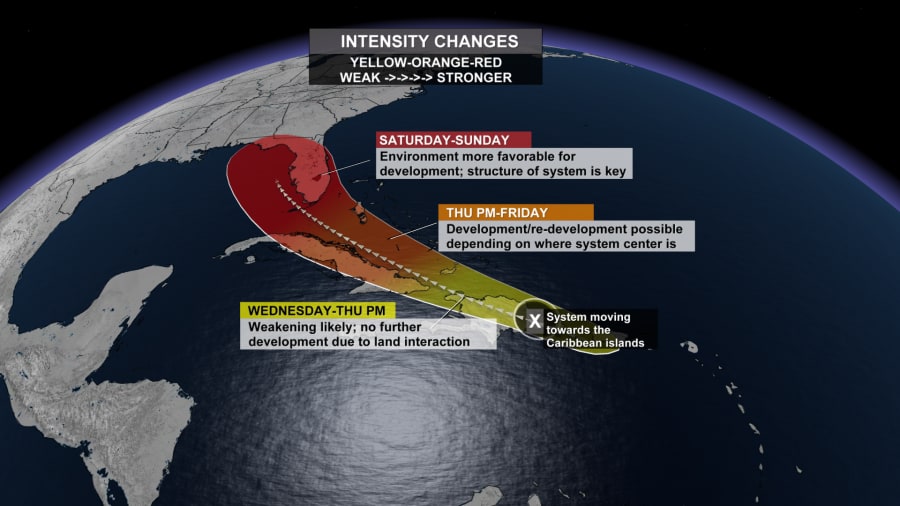
JACKSONVILLE, Fla. – Tropical depression Fred was moving along Cuba’s northern coast and could regain tropical storm status as it pulls away from the island on Friday, ahead of its projected track towards the Florida Keys on Saturday and southwest Florida on Sunday, forecasters said.
As of 2 p.m., Fred was producing heavy rain while moving west-northwest at 12 mph along the Cuba coast and sitting about 245 miles away from Key West.
Recommended Videos
The storm had maximum sustained winds of 35 mph Friday afternoon, according to the National Hurricane Center, but slow strengthening was expected late Friday through Saturday, and Fred is forecast to regain tropical storm strength as it nears the Florida Keys and south Florida.
On the forecast track, Fred is expected to be near the Florida Keys and southern Florida on Saturday with the current update keeping Fred generally weaker overall.
Sunday through Monday would be the earliest Fred could impact Jacksonville.
No evacuations are planned for tourists or residents in Monroe County, Keys officials said Friday. The county’s emergency management officials are advising people in campgrounds, recreational vehicles, travel trailers, live-aboard vessels and mobile homes to seek shelter in a safe structure during the storm.
Once a tropical storm, Fred weakened back to a depression by its spin over Haiti and the Dominican Republic, where it knocked out power to some 400,000 customers and caused flooding that forced officials to shut down part of the country’s aqueduct system, interrupting water service for hundreds of thousands of people. Local officials reported hundreds of people were evacuated and some buildings were damaged.
TRACKING THE TROPICS: Interactive tropical map and more

From Friday into Monday, 3 to 6 inches of rain is anticipated across the Florida Keys, the southern and central Florida Peninsula, and north toward the Big Bend of Florida, with isolated maximum totals of 8 inches.
Fred became the sixth named storm of the Atlantic hurricane season late Tuesday evening as it moved past the U.S. Virgin Islands and Puerto Rico.
Meanwhile, still east of the Caribbean Sea, forecasters were watching a disturbance that they said would likely become Grace, the seventh named storm of the Atlantic hurricane season. Island governments issued a Tropical Storm Watch for Antigua and Barbuda, St. Kitts and Nevis, and Montserrat. Puerto Rico and the U.S. Virgin Islands also were warned to monitor its progress.


