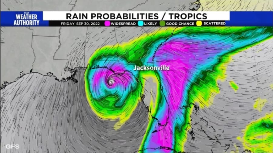
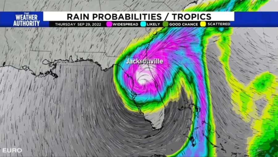
JACKSONVILLE, Fla. – Clarity is still not there in the forecast models for Tropical Storm Ian, despite a plethora of higher density data by the Gulf Stream Hurricane Hunter. This high-flying aircraft reaches up to 45,000′ and samples the atmosphere by dropping instruments (sonobuoys) out the back of the plane. These parachute down to earth and take temperature, humidity, and barometric pressure along the way. Additionally, wind direction and speeds are calculated. All great information fills in the gaps in data over the broad open waters surrounding tropical storms and hurricanes.
There was great hope that with better high-density data, the forecast models would agree better. Unfortunately, that hasn’t happened, and just three days before the rains begin to fall across Northeast Florida and Southeast Georgia, we are still attempting to figure out the potential impacts.
There are some positive signs. First, the slide to the left in the NHC cone forecast was pronounced and now places Jacksonville on the far eastern end of the cone. This suggests that we are unlikely to see the core of Ian pass through Jacksonville.
Ian is no Irma, and we should not anticipate similar impacts. Irma was a massive hurricane whose wind field was hundreds of miles wide. Ian will be rapidly weakening and a far smaller system should it track similar to the Euro projection (see picture below).
Ian will intensify rapidly, and now there are strong indications that Ian will weaken rapidly as well, especially if Ian takes a more westerly track towards the Panhandle (Panama City).
Based on the current NHC cone forecast, Jacksonville should anticipate tropical storm conditions to spread across the area starting as light rains on Wednesday, a few heavy bands of downpours overnight into Thursday, followed by sun and scattered downpours with breezy conditions on Thursday.
Despite the anticipated track now being to Jacksonville’s west, we could still see squalls of rain that could have winds to over 45 mph, which may cause power outages. These power outages should be scattered.
There will also be the threat of tornadoes, which may happen at night, although more likely during a round of heavy storms Thursday afternoon/evening.
Here’s a brief overview of what Jacksonville will most likely see:
- Rains begin Wednesday during the day; moving up from the south, they will spread across South Georgia
- The heaviest rains will most likely be Wednesday night into Thursday morning
- Rainfall estimates still have a high range as the final track is unclear. Expect 1-5″
- Severe weather threat for tornadoes Thursday afternoon and evening
- We will update this as the forecast models become more in agreement
Here’s some good news, if the current NHC track west of Jacksonville holds, we can also expect:
- No evacuations of area beaches.
Personal note, the extreme forecast differences between the Euro and the GFS suggests there could be some huge shifting in thinking on the NHC track and what ultimately happens here in Jacksonville. With just 4 days to go, neither model has budged much in its projection. Yet, the spread between the two is some of the greatest I have seen for this part of the Atlantic Hurricane Basin.
Stay alert and continue to prepare your family and download the 2022 Weather Authority Hurricane Guide to your phone.
You might want to read these articles too!
Mark Collins: Potential Impacts


