The two most dominant weather forecast models are the ECMWF, also known as the EURO, and the GFS. They differ similarly to a sedan or a truck. Both get you somewhere but each has unique utility and is built differently.
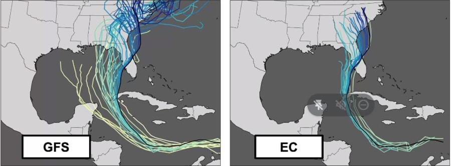
The results can lead to completely opposite tracks like what we saw with Hurricane Ian. Days before landfall the GFS indicated a hurricane near the Florida Panhandle and the EURO offered a path toward South Florida.
Recommended Videos
The EURO was closest to nailing where the Category 4 hurricane would cross near Fort Myers on Sept. 28. But it was by no means a clean victory since the GFS outperformed on intensity prediction.

The National Oceanic and Atmospheric Administration Global Forecast System, or GFS, and the EURO or the European Center for Medium Range Weather Forecasting in Great Britain give different predictions because of the differing mathematical physics underlying the computer code which leads to various forecast predictions.
Developers modify code to accept data with the goal of simulating the initial model conditions as close as possible to the real current weather conditions. Then the laws of atmospheric motion that underpin each model go to work projecting future weather.
But each model captures the timing or exact features of weather differently which can result in contrary projections.
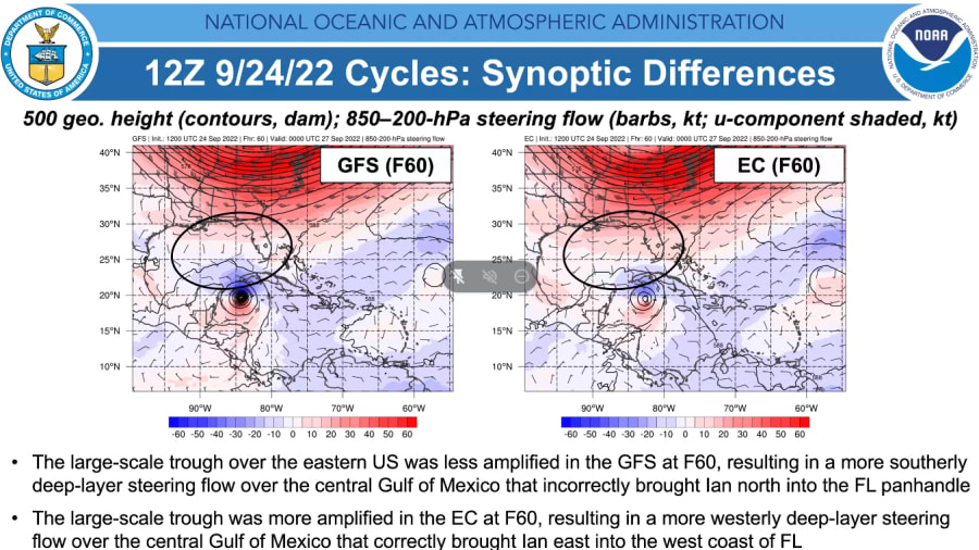
In this particular case with Hurricane Ian, models were so out of sync because they captured the current weather differently when the tropical cyclone was south of Cuba. The GFS was too weak anticipating an upper trough over the United States that should have kept Ian riding the southerly steering flow on a track north and out in the Gulf.
Instead, the stronger trough noted by the EURO began curving the path south of Tampa before the GFS picked up on that feature by September 27.
With Hurricane Ian, the GFS was left of the actual track or too far west, and the EURO was closer to the actual track if not too far east at times. Within 24 hours of landfall, both models had track errors under 60 miles.

GFS nailed the windspeed
The best model predicting Ian’s fierce 150 mph winds was hands down the GFS. It had the lowest intensity errors than any of the global models. In particular, a fork of the GFS catered to hurricane intensity forecasting called the HMON captured the rapid increase in windspeed remarkably better than others.
The GFS in the past has been runner-up to the EURO due to it having to output many more forecast products giving it a disadvantage to the streamlined European Centers suite of model products. But the tide is changing.
GFS becomes the new king of weather models
In the spring of 2021, the GFS got a significant upgrade in model physics which set it ahead of the European Center.
Under the hood, the GFS engine boosted its vertical resolution from 64 to 127 levels. In essence, it was like adding more megapixels to a camera helping the model see smaller weather features that were previously undetected. Ever since the upgrade, it has increased the identification of tropical cyclone threats with higher success and longer lead times.
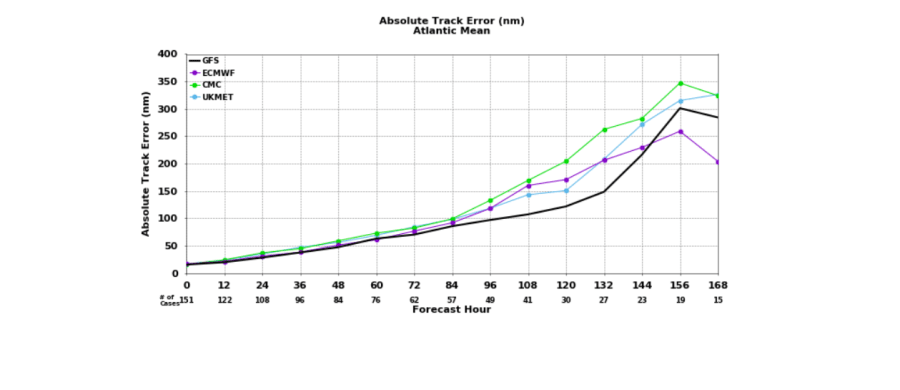
Other than Ian’s setback, the GFS has outperformed the EURO this year continuing 2021′s winning streak where it had the lowest tack error of any global model.

The additional data incorporated directly from weather satellites, as well as upper level wind, temperature and moisture observations from aircraft has improved GFS accuracy.
NOAA’s Environmental Modeling Center continues to make improvements to stay in the lead with the upcoming new hurricane model called the HAFS. It ran in experimental mode and predicted Hurricane Ian’s turn south of Tampa Bay earlier than the HMON.
The HFAS is expected to go operational for the 2023 hurricane season.


