JACKSONVILLE, Fla. – A possible derecho and multiple tornadoes impacted portions of Southern Plains on Sunday.
Several tornadoes were reported in Oklahoma and Texas, and wind gusts between 80-100 mph were recorded.
What is a derecho?
The majority of the damage from Sunday’s event was likely caused by a derecho, a widespread damaging wind event.
Derecho comes from the Spanish word “derecho,” meaning “right” or “straight ahead.” This word was used in the late 1880s to signify the difference between a straight-line wind event and a tornado.
According to the Storm Prediction Center, the word fell out of usage in the science community but returned in the 1980s to describe particularly intense straight-line wind events.
Derechos begin when a cluster of intense thunderstorms starts to increase in speed and starts to bow out. This is called a “bow echo” due to the fact that on radar, the line begins to take a bow shape.
This bow echo is capable of producing severe wind gusts and multiple tornadoes.

As the bow echo continues to move over land, it cools the air behind it, creating a “cold pool” relative to the air around it.
This cold pool helps develop more thunderstorm activity, preventing the bow echo from dissipating.
When the atmosphere ahead of this line remains unstable, the bow echo can intensify even further. The storms are now capable of producing significant downbursts, which are winds that push down from the inside of the storms.
These winds are often in excess of 80 mph.
Derechos are different that other storm systems due to their longevity.
It is not uncommon for derechos to last several hours, and sometimes over one day.
If wind damage from a thunderstorm complex extends 400 miles long and 60 miles wide, and widespread 58 mph wind gusts were recorded, plus several isolated 75 mph wind gusts, the National Weather Service rules the event a derecho.
Sunday’s event
Meteorologists were becoming concerned late last week of a possible derecho is the Plains states.
On Sunday morning, the Storm Prediction Center placed much of Oklahoma in a moderate risk for severe weather, highlighting the risk of severe winds and a possible derecho.
Unfortunately, the storms did develop, producing widespread damage.

One of the hardest hit areas was Norman, Oklahoma, a suburb just south of Oklahoma City.
There, numerous buildings were damaged, and 12 people were reported injured.
Multiple tornadoes were also reported on Sunday, including a couple that did structural damage in Oklahoma and Texas.
Thousands of residents remain without power in the Southern Plains, and the outages for some will likely last days.
Can a derecho happen here?
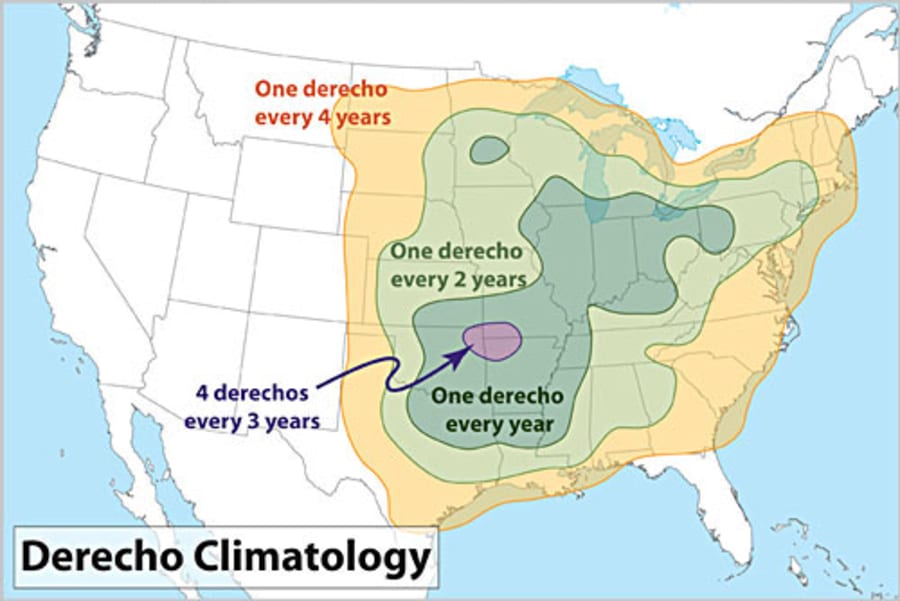
A derecho can happen in Southeast Georgia and Northeast Florida, but it would be a rare event.
Derechos often form in the Plains and Midwest states, where the differences in the airmasses can help to contribute to widespread thunderstorm development.
While storms are common in the summer months here, these develop due to sea breezes and atmosphere instability, and almost always fade away during the overnight.
That doesn’t mean it isn’t impossible.
The official derecho climatology from the Storm Prediction Center highlights all of Southeast Georgia with the average of having a derecho once every four years.

Derechos would be even harder to come by in Florida, where a derecho would a very rare occurrence.
The Plains and the Midwest average about one derecho a year, but an isolated spot where the Missouri, Arkansas and Oklahoma converge receives four derechos every three years.
The widespread damage from Sunday’s event will likely be ruled a derecho, but these types of weather events occur rarely in our part of the country.


