
TONIGHT’S FORECAST
Sunday evening temperatures will drop into the low 70s with winds shifting from the east to the south between 5 to 10 miles per hour. Humidity remains high. Clear skies and no rain for Sunday.
Monday morning begins with temperatures in the low 70s and upper 60s range, with winds from the south and southwest. Mostly clear skies remain. There is no chance of rain.

TRACK THE TIDES
https://www.weather.gov/jax/marineTides
COASTAL FLOOD ADVISORY EXTENDED until Tuesday 5 AM
LOCATIONS:
Inland St. Johns, Inland Flagler, Coastal Duval, Eastern Clay, Eastern Putnam, Trout River, South Central Duval
Areas could see flooding of lots, parks, and roads with only isolated road closures
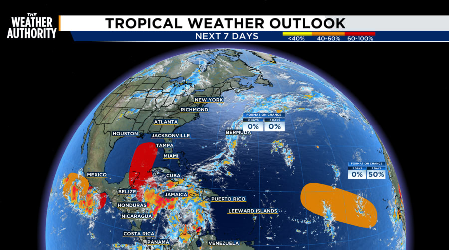
TRACKING THE TROPICS
There are currently three disturbances in the tropics or Gulf being monitored.
Central Subtropical Atlantic (AL96): Showers and thunderstorms have diminished in association with an area of low pressure located several hundred miles southeast of Bermuda. Development of this system is not expected due to dry air and increasing upper-level winds * Formation chance through 48 hours...low...near 0 percent. * Formation chance through 7 days...low...near 0 percent.
Northwestern Caribbean Sea and Gulf of Mexico: Disorganized showers and thunderstorms located over the northwestern Caribbean Sea and portions of Central America are associated with a broad area of low pressure. Environmental conditions appear favorable for the development of this system, and a tropical depression or tropical storm is likely to form during the next few days while moving northward across the northwestern Caribbean Sea and Gulf of Mexico* Formation chance through 48 hours...medium...40 percent. * Formation chance through 7 days...high...80 percent.
Eastern and Central Tropical Atlantic: A tropical wave near the west coast of Africa is expected to move westward during the next several days. Environmental conditions could support some gradual development of this system, and a tropical depression could form during the middle to latter part of the week while the wave moves westward across the eastern and central tropical Atlantic. * Formation chance through 48 hours...low...near 0 percent. * Formation chance through 7 days...medium...50 percent.
The next named storm will be Helene.
