
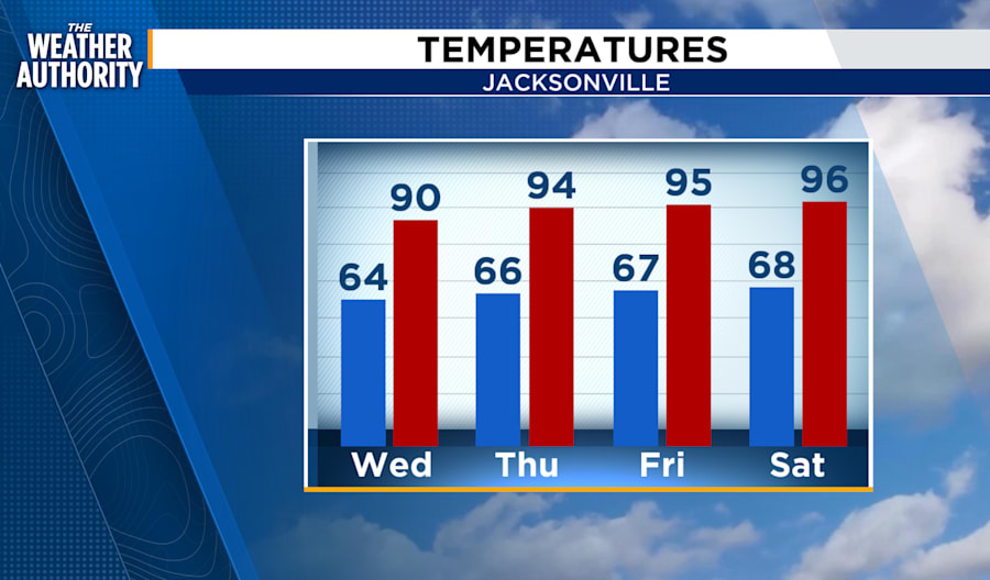
JACKSONVILLE, Fla. – It’s time to break out the iced drinks and sun hats! WJXT’s meteorologist, Richard Nunn, has forecasted a blistering heat wave making an entrance as the weekend wraps up and the new week begins. Expect daytime highs reaching the mid to upper 90s, providing the perfect excuse to fire up the grill or take a dip in the pool.
Current weather conditions and forecasts
While the heat is building up, a few brief showers are still sauntering around southeast Georgia. However, these are expected to fade, leaving the evening clear for any outdoor dining or plans under the stars.
For tonight, temperatures will hover in the 60s and 70s, with a mix of crisp and humid conditions.
Weather system movements
The showers are moving from the southwest to the northeast. There’s a slight 10% chance of precipitation, but nothing major. An offshore pattern will affect the beaches, promising westerly winds turning southward.
Sunny skies are predicted for those heading to the river or coast, with seas calming down to about 2 to 3 feet.
Share your weather photos
As we move into warmer days, nature’s beauty shines too! Magnolias are beginning to bloom, adding a Southern charm to the landscape. If you capture any picturesque moments, share them with us on SnapJAX!
Stay tuned to News4JAX and The Weather Authority, powered by Exact Track 4D, to keep updated on your local weather conditions.


