

Jacksonville, FL – Sea breeze showers and storms will be a part of Tuesday’s forecast with widespread showers and thunderstorms developing Wednesday and continuing through the rest of the week.
Tonight: Partly cloudy skies with patchy fog overnight.
Tuesday: Near seasonal temperatures with a slight chance of sea breeze showers and storms, mainly after 2 p.m., 30- 40 percent. Morning lows in the 60s and 70s. Afternoon highs in the 80s to low 90s. Wind ESE 10-15 mph. Becoming cloudy late.
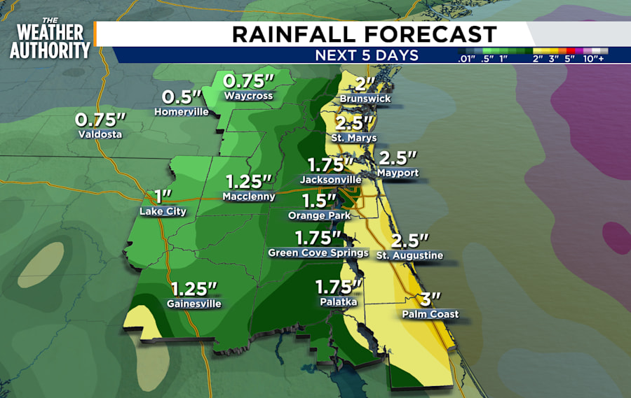
Wednesday - Friday: A weak front will lift north, bringing an increased chance of widespread rain with thunderstorms each day. Estimated rainfall accumulation through Friday will average around 0.50 to 1.50 inches for inland areas while coastal zones could see 2 - 4 inches. The current severe weather risk is low through the period.
Weekend: The southwesterly winds return. Scattered showers with storms will develop along the sea breeze each day.
Tropics: Two days in and we are watching an area of possible development along the Atlantic in the southeast. Chances for development are 0 percent and 10 percent over the next 2 to 7 days.
Sunrise: 6:25 a.m.
Sunset: 8:25 p.m.
