After what the Bahamas just endured with Hurricane Dorian, all eyes are keeping watch on what the National Hurricane Center is saying about a new area of disturbance that could become "Humberto."
The same early differences we saw in the tropical models with Dorian continue with this potential tropical system, meaning two vastly different impacts for our area: Either a very soggy weekend for the entire area or more of a coastal impact with less wind than we saw with Dorian.
Recommended Videos
The National Hurricane Center has been monitoring the area of disturbed weather moving toward the Southern Bahamas for days, but as of Thursday morning the chances of it developing have been increased to 70% over the next two days and 80% over the next five days.
A hurricane hunter aircraft is scheduled to fly through the system Thursday afternoon. They will look for maximum sustained winds, lowest minimum central pressure and for a center of rotation. Based on what they find, this system may be declared a Tropical Depression or a Tropical Storm.
John Gaughan: Watch system in Caribbean closely, a lot could change
There is a large amount of uncertainty in the future path of this system. The two predominant forecast models we rely on for hurricane forecasting vary enough to be drastically different for what we could expect.
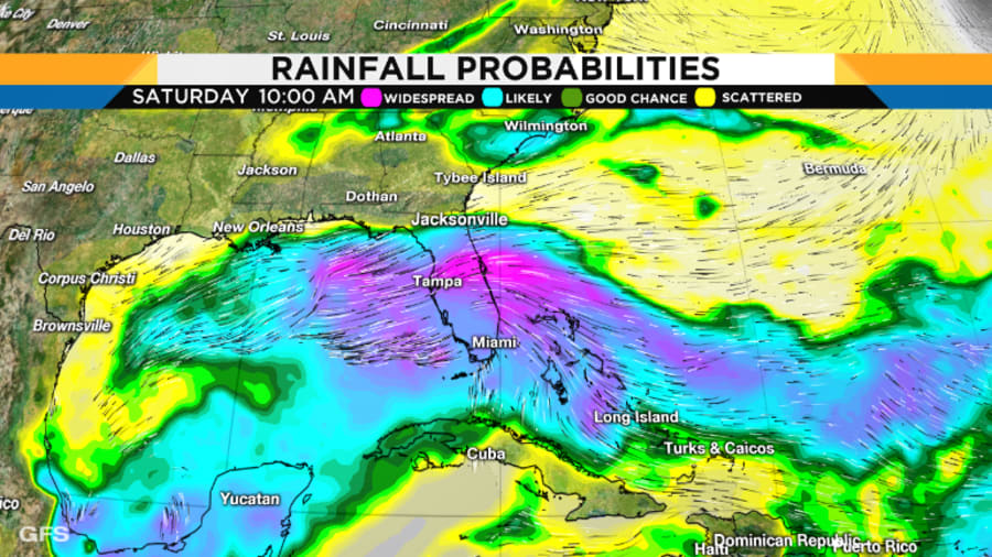
The GFS forecasts the system moving over the peninsula of Florida, which would mean it would not intensify into a strong storm. While remaining weak, this would mean wet conditions for nearly the entire area over the weekend. The worst our area could see with this forecast would be local flooding under tropical rainfall.

This graphic shows what the GFS model predicts for this system over the weekend. It is so weak there are not strong winds or a defined center of circulation. It shows widespread areas of tropical rainfall spreading across the state and eventually making its way toward the panhandle and Gulf. This forecast would mean northeasterly winds around 20 mph and passing waves of rain. Nearly every area would have good chances to see rain with this model. It would not be limited to coastal areas.

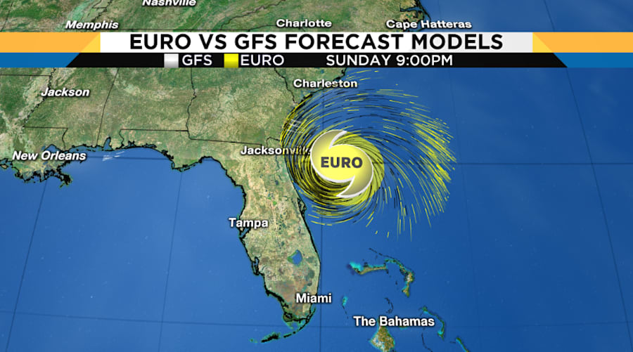
And then there is the Euro, pictured on the right. This forecast model develops the system into a Hurricane and keeps it off of the Florida coast as it curves off to the north and then northeast. The current model run keeps the system even further to the East and away from our coastline than what we saw with Dorian. If this were to occur we would see even less rain and wind than what we saw with Dorian. This model would bring some slight beach erosion and coastal county rainfall.
Satellite images indicate that the area of disturbed weather over the central and southeastern Bahamas is gradually becoming better organized while surface pressures are falling in the area.
Conditions are becoming favorable for a tropical depression or a tropical storm to form within the next day or so as the system moves toward the northwest through the northwestern Bahamas and toward the Florida Peninsula at 5 to 10 mph. If this development trend continues Potential Tropical Cyclone advisories will likely be initiated later today. This disturbance will bring heavy rainfall and gusty winds across portions of the Bahamas through Friday, especially in portions of the northwestern Bahamas affected by Hurricane Dorian.
Here’s a quick video of our #ReserveCitizenAirmen heading out for invest 95L.#ReserveReady #403WG #WC130J #SuperHercules #HurricaneHunters #WeatherReady #NWSNHC pic.twitter.com/U5KQMosfIW
— Hurricane Hunters (@53rdWRS) September 12, 2019


