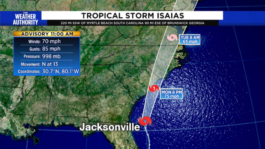
Isaias is now expected to intensify into a Category 1 Hurricane again after it churns past Northeast Florida this morning.
Despite this, impacts will be minimal for our area. Expect coastal clouds and a round or two of coastal showers, along with winds at the beach between 15 to 20 mph. Expect very rough surf and deadly and dangerous rip currents to be the highest impact on us from Isaias.
Recommended Videos
As of 11 a.m., Tropical Storm Isaiah was about 90 miles east-southeast of Brunswick, moving north at 13 mph with 70 mph winds. The latest track is little changed from 5 a.m., with the cone of uncertainty way out in the coastal waters east of Jacksonville’s coast.
Tropical storm warnings remain in effect for numerous coastal counties in the area, including Camden, Duval, Flagler, Glynn, Nassau and St. Johns, although the tropical storm warning remains in effect for St. Johns and Flagler counties, the storm surge watch has been discontinued.
MORE: Interactive tracking map | Watches warnings | Radar & Skycams: Choose your view

The first of what will be many rain bands moved onshore Sunday afternoon and continued overnight and into early Monday. Brief intense downpours lasting from minutes to up to 15 minutes will have strong gusty winds associated with them as well.
The system’s circulation has expanded in an asymmetrical fashion, which means the majority of the rain staying offshore. Impacts to Northeast Florida will not result in significant threats other than some winds possibly gusting to near 40 mph Monday morning.
Rain and gusty winds are still in the forecast Monday morning which makes a messy start to the week.
Here’s video 📹 of today’s mission into TS #Isaias. Make sure to check out :37 sec & watch an AXBT deployed.
— Hurricane Hunters (@53rdWRS) August 3, 2020
✈️⛈🌪🌊#ReserveReady #ReserveResilient #ReadyAF #WeatherReady #WC130J @403rdWing @NOAA_HurrHunter @NWS @NHC_Atlantic pic.twitter.com/l2ghsb2JxN
It is no surprise the system weakened as tremendous dry air and shearing winds dealt a heavy blow to the strengthening process.
A tropical storm warning still covers most of the east coast of Florida and Georgia’s east coast, and up to 3″ inch of coastal rain is possible. The heaviest rain will be early Monday morning. Yes, a few locations may see up to 3″, most however, will see closer to an inch and that amount will also be true for some of our inland counties as well. Clay, Bradford, Baker and Charlton counties may also see up to an inch.
The reduction in the initial and predicted intensity of Isaias has necessitated changes in warnings along the east coast of Florida. The Hurricane Warning along the east-central coast of Florida has been replaced with a Tropical Storm Warning.
RELATED: How will Isaias impact Jacksonville area?
The greatest impact along Northeast Florida’s coastline will be around sunrise Monday. Coastal Georgia will get the most wind and rain later on Monday morning.
Local impacts could be that of a weak tropical storm along the coast at worst, but in all actually more like a breezy Nor’easter -- with some inland locations seeing no noticeable weather.
Unlike the hurricanes we have seen, Tropical Storm Isaias will bring in bands of rains followed by sunshine and then more bands of rains through noon Monday. In a video taken at 1 p.m. Sunday, the first rainband of Isaias can be seen nearing Jacksonville Beach. Surf was 3-5 feet, and tide was at low tide, so the beach was wide. This will not be the case at 8 a.m. Monday. That’s the time of high tide. There will be some overwash as tides will be about 1-2 feet above normal.


